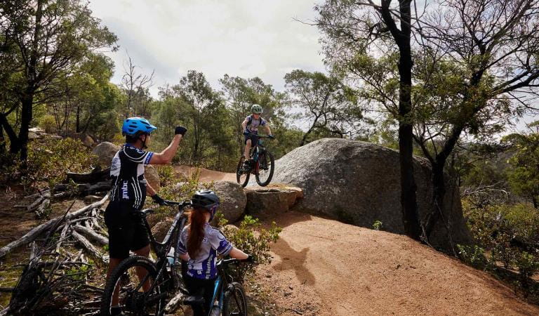
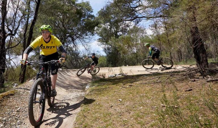
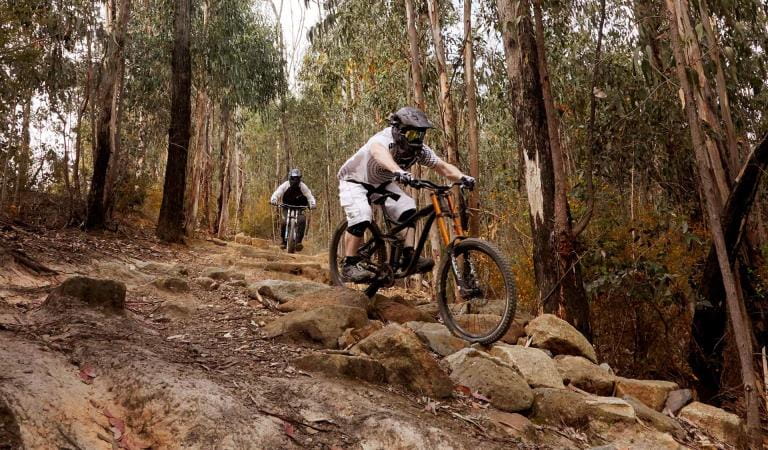
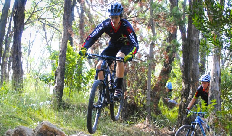
The steep terrain and tall canopy of the Silvan area of Dandenong Ranges National Park makes for an exciting mountain bike destination, hosting a combination of single trail and management vehicle tracks with opportunities for beginner and intermediate skill level.
The area has 13km of dedicated mountain bike trails and a significant management vehicle track network suitable for riding. The trails can be enjoyed individually, with friends or you can join a local riders club.
The mountain bike trails are managed by Parks Victoria with the support of the local club - Yarra Ranges Mountain Bikers (YRMTB). If you’re interested in being involved in building new trail features or helping maintain trails, get in touch with Parks Victoria or YRMTB to volunteer.
Things to do

RJ Hamer Arboretum

Dandenong Ranges Botanic Garden

Doongalla Homestead

Kalorama Park

Olinda-Falls

William Ricketts Sanctuary
How to get there
Mountain bike trails in Dandenong Ranges National Park
If visiting by car, start your mountain bike trail experience from the Silvan Reservoir Picnic Area. Facilities include parking, toilets, picnic tables and barbeques. From the picnic area, head 500m south west on Stonyford Road until you access the Track 13 management vehicle track which will take you into the “Forest Flow” trail network.
Alternatively, park at RJ Hamer Arboretum and head east along Chalet Road to start at descending Blue Grade Huds Track.
Facilities
When you're there
Parks Victoria rangers endeavour to keep the trails open in just about all conditions. However, short closures may occur in extreme weather events, after storms or to conduct trail works.
Download a map of the mountain bike trail to find out more.
Need to know
Mountain bike trails in Dandenong Ranges National Park
Change of Conditions
Nature being nature, sometimes conditions can change at short notice. It’s a good idea to check this page ahead of your visit for any updates.
-
Dandenong Ranges National Park
Temporary closed areas due to deer control activities
Parks Victoria are continuing deer control in the Dandenong Ranges National Park. This program will be taking place between the hours of 4pm and 7am on a number of nights between February 13th 2024 and November 29th 2024. These control works are being undertaken by accredited and authorised contractors.For reasons of public safety, various areas of the park will be inaccessible during the evening throughout this period.Signage will be in place at access points when control activities are occurring. For your own safety please observe the signage during this time and do not enter any closed areas.For further information please call 131963Attachments: Neighbour_Notification_Map_DRNP_2324 (2,529KB)
Deer control in the Dandenong Ranges National Park
Parks Victoria are continuing deer control in the Dandenong Ranges National Park. This program will be taking place between the hours of 4pm and 7am on a number of nights between the 1st of November 2023 and the 30th of November 2024. These control works are being undertaken by accredited and authorised contractors.For reasons of public safety, various areas of the park will be inaccessible from dusk until dawn throughout this period.For your safety please observe all closure signage during this time and do not enter any closed areas.For further information please call 131963Attachments: Neighbour_Notification_Map_DRNP_2324 (2,529KB)
Track 13 - Silvan Storm Recovery Works Notification
FFMVic Storm recovery works will take place in the Dandenong Ranges National Park near Silvan.
Date: April to May 2024
Duration: Works will take place from April and are expected to be completed by 30 May 2024, weather and forest conditions permitting
Location: Track 13, near Silvan Reservoir Park, Silvan (see map)
Impact:
Mountain bike and walking tracks in the area will be closed while the works are underway. For your safety, please follow track closures or detours.Tracks closed include:- Bakers Dozen Loop Track
- Downhill Track
- Link Track
- Magpie Loop Track
- Pipeline Track
- Track 11
- Track 12
- Track 24
Why:
FFMVic is continuing to remove fallen debris along key fire access roads and fuel breaks to make the Dandenong Ranges National Park safer for everyone. It’s important to undertake maintenance of the strategic fuel break network to reduce the rate of spread of bushfires and provide vital protection for communities.
This block sits within a Bushfire Moderation Zone, which aims to reduce the intensity, rate of spread, and ember loads from significant bushfires.
The protection of environmental, biodiversity and cultural values during all recovery and bushfire risk reduction works are a high priority.For more information about bushfire risk reduction activities visit the FFMVic website or call 136 186.Attachments: FFMVic Track Closure Map (554KB)
- Bakers Dozen Loop Track
-
Olinda Falls Picnic Area (Dandenong Ranges National Park)
Mechanics Track closed between Mt Dandenong Tourist Road and Falls Road
- Mechanics walking track from the Mt Dandenong Tourist Rd through to Falls Rd is closed due to significant damage from the June 2021 Storm. Parks Victoria is currently working with insurance assessors and contractors on a plan to re-open this severely impacted walking track.
- Works completed so far has been the replacement of a timber bridge that was destroyed along with most of the large fallen trees having been cut through, the remaining walking track requires re-benching and tree branch removal where limbs have been partly buried due to the force of the impact with the ground. Works are expected to be completed by June 2024.
Olinda Falls Toilet Closed
The Olinda Falls toilet is closed indefinitely, nearby toilets at Kalorama Park or in the Olinda Township are open.Olinda Falls Lower Viewing Platform - update
The Olinda Falls lower viewing platform is currently closed due to severe damage caused by a fallen tree. All access to the lower falls area is closed to the public. The viewing platform is expected to be replaced sometime in 2024.
-
Sherbrooke Track (Dandenong Ranges National Park)
Wattle Track Bridge Closure Update
Wattle Track Bridge in Sherbrooke Forest is closed due to significant structural damage to the Foot Bridge by a fallen tree. Parks Victoria has engaged a contractor to commence construction works in March 2024, it is anticipated that the bridge will be opened by May 2024. The existing damaged timber bridge will be replaced with an all steel constructed bridge which includes a non slip FRP decking, during the construction period there may be some delays along Sherbrooke Track as building materials are carried to the site, Sherbrooke track will remain open. -
Valley Picnic Ground (Dandenong Ranges National Park, RJ Hamer Arboretum)
Valley Picnic Ground Closed
- Valley Picnic Ground is closed, the site will eventually be improved after it was damaged in the June 2021 Storm event ; visitors can use Boundary Road to access the park however no vehicle access to the picnic ground carpark is permitted. Please use Eagle Nest or Kalorama Park Picnic Ground as an alternative.
Similar Trails
Mountain biking at Lysterfield Park
Bowden Spur Mountain Bike Area
Mountain biking in Arthurs Seat State Park